Maps
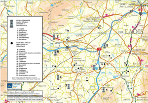
Maps are helpful for understanding where we all come from. Important Fitzpatrick locations on maps of Laois are Mountrath, Castletown, Aghaboe, Borris-in-Ossory, Ballaghmore, Errill, Rathdowney, Clough, and Cullahill. Counties Cavan, Clare, Down, Dublin, and Kilkenny all have historically significant populations of Fitzpatricks as well, and maps can help us pinpoint our ancestry by townland or parish.
Click on the images and links to see Fitzpatrick maps. Nearly all of these sites will also allow you to search other Irish surnames and locations as well.
Ordnance Survey
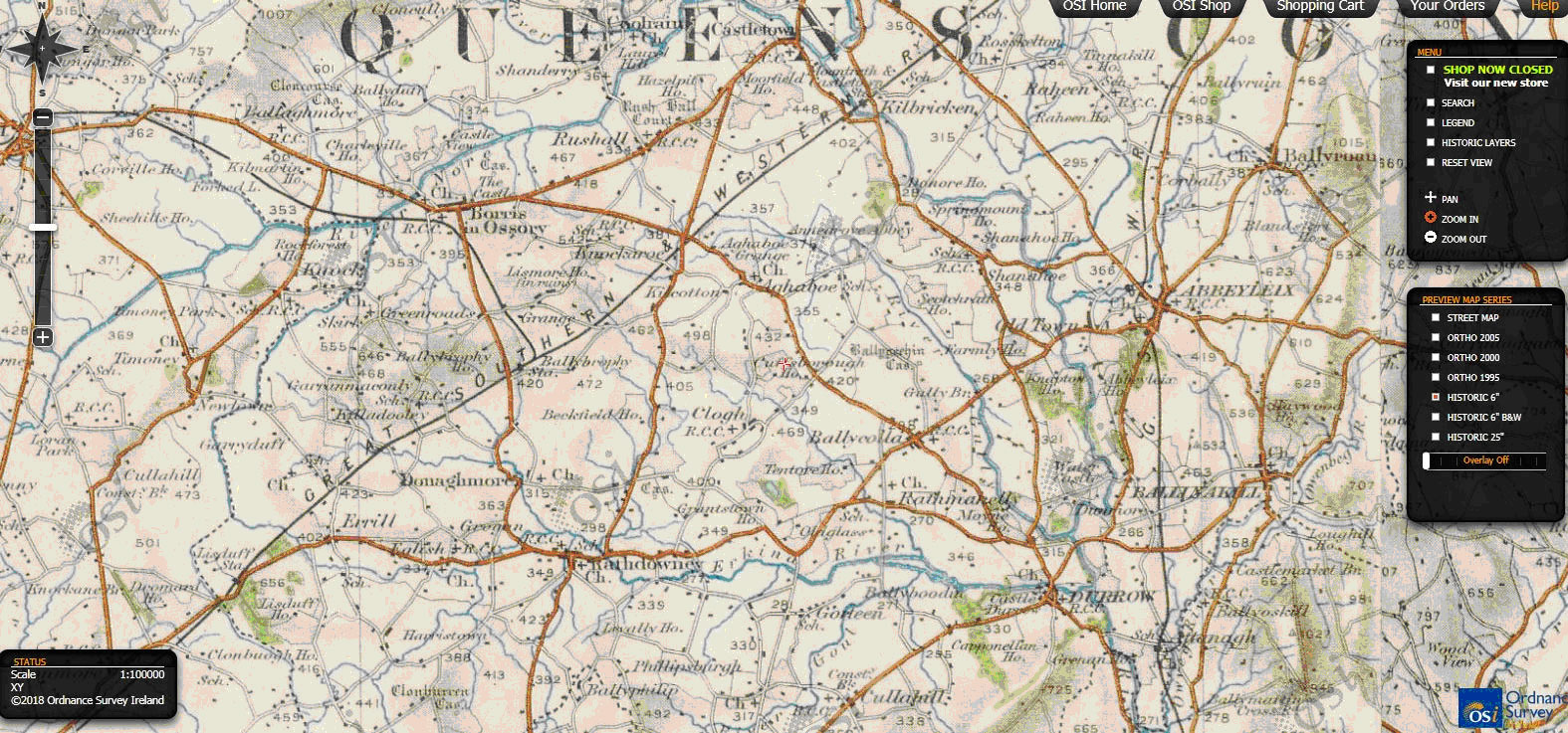
This Ordnance Survey of Ireland website allows visitors to access their official maps of Ireland online. A useful feature for genealogists is the facility which allows the OSI’s older maps to be superimposed so that users can study how a selected location has changed over time.
Our view of the map opens to show the Historic 6” map at Rathowney in the heart of Upper Ossory. To the left you can click the compass points to navigate N, S, E, W and the slide bar to increase/decrease the view scale. Use the second slide bar at lower right panel to see the Overlay effects. Or select Historic Layers in the upper right panel to see the embedded options that are available. You can add and remove details like locations of churches, graveyards, schools, or whatever your genealogical interest by simply selecting the appropriate box.
The Down Survey of Ireland
View an interactive map of William Petty's 1655 -1656 survey of Ireland, by zooming in scrolling to anywhere in Ireland. Search by County, Barony, and Parish name.

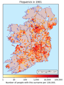
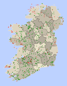
Barry Griffin's detailed maps based on the 1901 and 1911 censuses, showing geographic surname distribution, land ownership, surname rank, various religious affiliation, and spoken language. Many Irish names and variant spellings are included in this site, so feel encouraged to browse any name or related spelling; for example: FitzPatrick, Fitz Patrick, Kilpatrick, or Costigan.
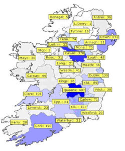
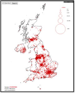
Irish Surname Distributions, mid-1800’s, by S. Wilson
Type the name Fitzpatrick, or any Irish surname into the search box to view historic distribution by county. The darker the color of the county, the higher the density for that surname distribution. Darker blues mean higher numbers of that surname within a County.
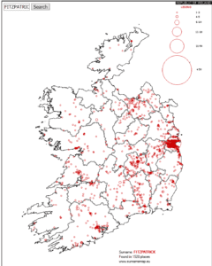
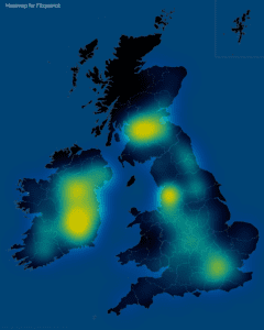
John Grenham's site offers tons of information for every Irish surname; see this page on Fitzpatrick and its distribution based on Griffith's Valuation (1847-64). (A separate map with all Fitzpatrick surname variants is here.)
Mapping the Emerald Isle: a geo-genealogy of Irish surnames; by esri
Use this map to view different regions where Irish surnames hail from. Look for the name Fitzpatrick, or any variants. To view this page ensure that Adobe Flash Player version 10.2.0 or greater is installed.
Rob Spencer's very illustrative interactive site allows you to enter a surname or y-DNA SNP and view maps, charts, graphs and more.
Google Maps
Google Maps offers a view of modern Ireland. Search for placenames.
Old Maps Online let's you look at historic cartography from various time periods all over the world at various resolutions. We've highlighted Ireland here. You can zoom in on the island and choose from a list of available maps which cover specific areas. The historic maps themselves are zoomable, and are often richly ornamented.
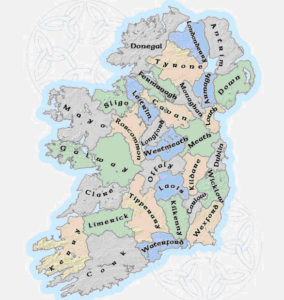
An on-going project based on data from OpenStreetMap, Townlands.ie offers a list of each county to see baronies, civil parishes and townlands. This is very helpful when looking at ancestral origins.
Search any placename in Ireland, and see distribution maps for placenames containing specific words in Gaeilge.

Forebears.io
See the maps and basic statistics which Forebears.io generates for the world distribution of the Fitzpatrick surname.
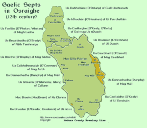
Ireland History in Maps: The Osraighe Region
Dan Walsh's site is packed with information from the annals, with reams of information on ancient tribal names; clans, surname locations by county, timelines, and more. Explore this site because it is very large, and covers the whole island.
Irish Kingdoms
Map of major medieval Irish kingdoms. Osraige highlighted; click to enlarge.

Clan Society Research
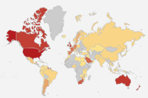
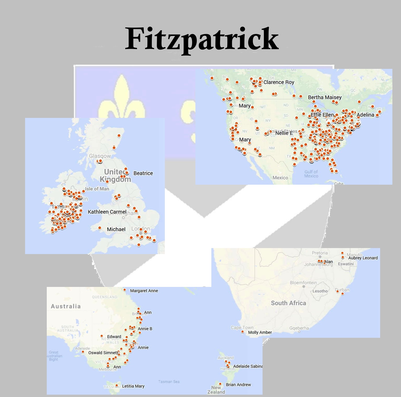
Fitzpatricks Around the World
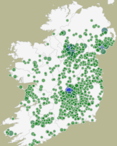
Where are Fitzpatricks around the world? A long-term project has begun that will place Fitzpatricks on a world map that are stored in your genealogical program. GEDCOM files created from nearly any genealogical program may be submitted. If your data meets criteria for accurate mapping, your Fitzpatricks can be included.
Initial results use contributions from those that have submitted to The Collection of Fitzpatrick Research. Samples of the results can be seen here. Each point on a map represents at least one Fitzpatrick and will include the name, location, events (birth, christening, death, burial, etc.), and date. In addition, the initials of the contributor will allow you to contact them for additional information if needed. Google Maps and Google Earth will be used to display the maps. A tabular format sorted by any column will also be available to help locate possible family members.
Notices will appear on The List as we approach the need for your GEDCOM files. If you want to see your Fitzpatricks on a world map, ensure that your events have a city, county, state, and country for each. Some countries have different names for these jurisdictional levels. Use the ones appropriate for the country.
Looking forward to seeing your Fitzpatricks join other Fitzpatricks around the world.
-Steve Zalewski
Map of historic Fitzpatrick castles, tower houses (habitable or impressive ruin), castle sites, and other sites (minor ruin or no visible trace). Copyright 2013, Steve Zalewski & Ronan Fitzpatrick.
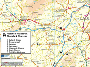
Map of historic Fitzpatrick churches, chapels, graveyards, and memorial sites. Copyright 2013, Steve Zalewski & Ronan Fitzpatrick.